The analysis of microwear on archaeological stone tools to identify tool function is integral to our understanding of past human behaviors.
Traditionally, archaeologists have used a combination of stereomicroscopy and reflected-light microscopy to identify wear traces on stone tools. However, blind tests of experimentally used stone tools have shown that these optical methods often result in the misidentification of tool use.
Thus, archaeologists are beginning to experiment with the application of surface metrology methods, such as confocal microscopy, for the quantification of wear traces.
“Our current project is using confocal microscopy to understand how hunter-gatherers at large aggregation sites used stone tools approximately 20,000 years ago” explains Danielle Macdonald, Assistant Professor at the University of Tulsa, Department of Anthropology.
“During this period, most people lived in small, mobile bands. However, they periodically came together in large groups at aggregation sites. We are exploring the range of activities at these sites and how domestic space was organized in large groups.”
“We suggest that the social activities at large hunter-gatherer sites set the stage for later sedentism during the origins of agriculture.”
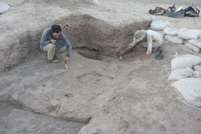
The Kharaneh IV site
“To understand these social processes we analyzed a collection of stone tools from several hut structures at the archaeological site of Kharaneh IV, Jordan (see photo above). Kharaneh IV is the largest aggregation site from the period before agriculture and contains several structures dating to approximately 19,000 years ago.”
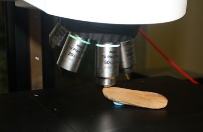
Above. Hide working stone tool analyzed with the Sensofar S-Neox
Sample preparation & analysis
- Prior to microwear analysis, the tools are cleaned using chemical cleaning methods to remove traces of sediment and grease.
- Using a white-light confocal microscope (Sensofar S-Neox) housed in the Surface Metrology & Tribology Lab at the University of Tulsa, Oklahoma, each tool is evaluated to identify microwear traces.
- Scans of worn areas are taken and the resulting data is processed in MountainsMap®. The worn areas are isolated to remove any unworn surface from the measurements. Next, the scans are filtered to remove form and waviness to measure surface texture. Surface parameters from ISO 25178 are applied to characterize the texture of the worn areas on each tool.
“Previous experimental work has shown that Sa (Arithmetical mean height) and Sq (Root-mean-square height) parameters yield significant differences in the texture of polish for stone tools used to work different materials (such as bone, wood, meat and antler).”
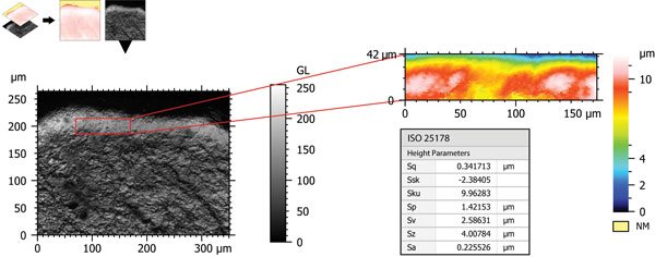
Above. Stone tool used to work hide analyzed with MountainsMap®. The worn area of the tool is isolated, visualized in 3D mode and surface parameters from ISO 25178 applied to quantify the worn surface texture.
Some preliminary results
“Although the research is ongoing, our current results show that people at Kharaneh IV stored tools used to scrape hide, possibly to use as clothing, in their houses but did not keep hunting weapons in their domestic space.”
“Using SensoMap based on MountainsMap® software for the quantification of wear traces on stone tools allows us to identify past human activities. The results from this research contribute to our knowledge of the activities performed at aggregation sites prior to sedentism and to our understanding of how hunter-gatherers interacted and negotiated social relationships in large complex groups prior to the origins of agriculture.”
About the author

Danielle Macdonald, Assistant Professor
Department of Anthropology
University of Tulsa
Projects:
- Kharaneh IV Excavation Project. Co-directed with Dr. Lisa Maher (University of California, Berkeley)
- Fragmented Heritage Project (University of Bradford)
Instruments & software used
Sensofar S-Neox 3D optical profiler + SensoMap analysis software based on MountainsMap®